 |
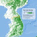
Tree cover of the Korean Peninsula
The map below shows the percentage of land covered by tree canopy (based on data by the U.S. Geological Survey from 2010) together with a (...)
February 12, 2018 – Jakub Marian – Maps
|
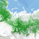 |
Tree cover of Russia
The Russian and Scandinavian taiga together form the largest continuous forest on Earth, covering an area of more than 8 million km2, (...)
February 5, 2018 – Jakub Marian – Maps
|
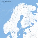 |
Water bodies of Scandinavia and Baltic states
Did you know that around 10.2% of the area of Finland, 8.9% of Sweden, and 6% of Norway is covered with freshwater? Each of these (...)
January 29, 2018 – Jakub Marian – Maps
|
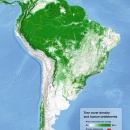 |
Tree cover and urban areas of South America
The map below shows the percentage of land covered by tree canopy (based on data by the U.S. Geological Survey from 2010) together with (...)
January 22, 2018 – Jakub Marian – Maps
|
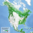 |
Tree cover and urban areas of North America
The map below shows the percentage of surface (green) covered by tree canopy (based on data by the U.S. Geological Survey from 2010) (...)
January 15, 2018 – Jakub Marian – Maps
|
By the way, have you already seen my brand new web app for non-native speakers of English? It's based on reading texts and learning by having all meanings, pronunciations, grammar forms etc. easily accessible. It looks like this:

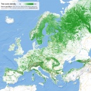 |
Tree cover of Europe
The map below shows the surface percentage covered by tree canopy (based on data by the USGS from 2010). Simply put, green areas represent (...)
January 8, 2018 – Jakub Marian – Maps
|
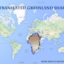 |
How big are Greenland and Russia in comparison to Africa?
We are all used to seeing the following kind of maps in Google Maps and other map providers (this one, in particular, is taken from Google (...)
July 7, 2014 – Jakub Marian – Maps
|