 |
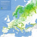
Forests of Europe Map
The map below is based on data by the European Space Agency (the CCI project). It shows the two different types of forests in Europe: dark (...)
October 29, 2018 – Jakub Marian – Maps
|
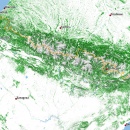 |
Tree cover of the Pyrenees
The Pyrenees are a mountain range that forms a natural border between Spain and France. Just like most other European mountain ranges, (...)
October 1, 2018 – Jakub Marian – Maps
|
 |
Land cover of Europe
The map below is based on data by the European Space Agency (the CCI project). It shows Europe and adjacent parts of Asia and Africa with (...)
May 7, 2018 – Jakub Marian – Maps
|
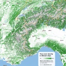 |
Tree cover of Western Alps
The Western Alps are part of the Alps, the highest and most extensive mountain range system in Europe. The Western Alps include parts of (...)
March 19, 2018 – Jakub Marian – Maps
|
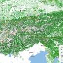 |
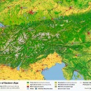
Tree cover of Eastern Alps
The Eastern Alps are part of the Alps, the highest and most extensive mountain range system in Europe. The Eastern Alps include parts of (...)
March 12, 2018 – Jakub Marian – Maps
|
By the way, have you already seen my brand new web app for non-native speakers of English? It's based on reading texts and learning by having all meanings, pronunciations, grammar forms etc. easily accessible. It looks like this:

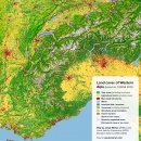 |
Land cover of Western Alps
The Western Alps are part of the Alps, the highest and most extensive mountain range system in Europe. The Western Alps include parts of (...)
February 26, 2018 – Jakub Marian – Maps
|
 |
Land cover of Eastern Alps
The Eastern Alps are part of the Alps, the highest and most extensive mountain range system in Europe. The Eastern Alps include parts of (...)
February 19, 2018 – Jakub Marian – Maps
|
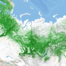 |
Tree cover of Russia
The Russian and Scandinavian taiga together form the largest continuous forest on Earth, covering an area of more than 8 million km2, (...)
February 5, 2018 – Jakub Marian – Maps
|
A small but necessary interruption: This website does not contain any ads and is completely dependent on the support of its readers. If you enjoy reading articles here, please, consider helping by using my web app for English learners.
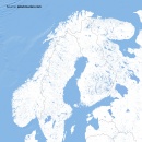 |
Water bodies of Scandinavia and Baltic states
Did you know that around 10.2% of the area of Finland, 8.9% of Sweden, and 6% of Norway is covered with freshwater? Each of these (...)
January 29, 2018 – Jakub Marian – Maps
|
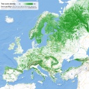 |
Tree cover of Europe
The map below shows the surface percentage covered by tree canopy (based on data by the USGS from 2010). Simply put, green areas represent (...)
January 8, 2018 – Jakub Marian – Maps
|